Anthromes
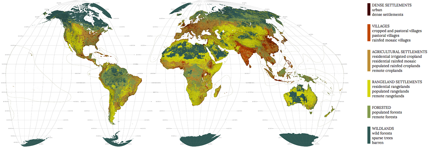
Based on the cartography of Erle C. Ellis, Navin Ramankutty, and others this map shows biomes to include anthropogenic effects on biodiversity and the consequent emergence of novel ecosystems. Novel ecosystems are defined as “[s]ystems that differ in composition and/or function from present and past systems as a consequence of changing species distributions, environmental alteration through climate and land use change and shifting values about nature and ecosystems.” 1 Unlike maps which show biomes or ecoregions as they would be in a world without humans, Ellis and Ramankutty’s anthromes mapping tell a story of “human systems with natural ecosystems embedded within them.” 2 The anthromes map is emblematic of the new epoch of the Anthropocene, a geological period characterized by the fact that humans have irrevocably altered the earth system and that humanity is a part and parcel of that system.
Ellis and Ramankutty propose a system of six groups subdivided into a total of 21 anthromes. The six groups are: dense settlements, villages, croplands, rangeland, forested, and wildlands. The anthromes are: urban, dense settlements, rice villages, irrigated villages, cropped and pastoral villages, pastoral villages, rainfed villages, rainfed mosaic villages, residential irrigated cropland, residential rainfed mosaic, populated irrigated cropland, populated rainfed cropland, remote croplands, residential rangelands, populated rangelands, remote rangelands, populated forests, remote forests, wild forests, sparse trees, and barren.
This map, based on 2008 data, shows that rangeland biomes are the most extensive, covering nearly a third of global ice-free land, while cropland biomes are the second most extensive of the anthropogenic biomes, covering about 20% of Earth’s ice-free land. Wildlands without evidence of human occupation or land use occupies 22% of Earth’s ice-free land. 3
This amount of wildland would seem to contradict the 2020 Convention on Biological Diversity’s (CBD) aim of achieving 17% global protected area upon which this atlas is based. It is important to note, however, that the convention mandates that such (ostensibly) wild land cannot be just some large remote alpine tracts for which humans have no other use. On the contrary, according to the CBD protected area must be ‘representative’ and therefore distributed throughout the world’s 867 ecoregions.
1 James A. Harris, et al., “Ecological Restoration and Global Climate Change,” Restoration Ecology 14, no. 2 (2006): 170-176.
2 Erle C. Ellis & Navin Ramankutty, “Putting people in the map: anthropogenic biomes of the world,” Frontiers in Ecology and the Environment 6, no. 8 (2008): 439–447.
3 Ibid.
Map created by Richard Weller, Claire Hoch, and Chieh Huang using data/information from the following sources:
1. Anthromes
E. C. Ellis & N. Ramankutty, “Putting People in the Map: Anthropogenic Biomes of the World,” Frontiers in Ecology and the Environment 6, no. 8 (2008): 439-447. Dataset: Anthropogenic Biomes of the World, v1 (2001-2006), developed by E. C. Ellis & N. Ramankutty, distributed by the NASA Socioeconomic Data and Applications Center (SEDAC) of the Center for International Earth Science Information Network (CIESIN) / Columbia University, http://sedac.ciesin.columbia.edu/data/set/anthromes-anthropogenic-biomes-world-v1 (accessed November 20, 2014). NB The color scheme used was created by grouping dataset categories together based on generalized types of human occupation.